|
|
||||
|
||||
 |
||||
|
Reservoir Committee Meetings for 2017
Committee Minutes and Agendas
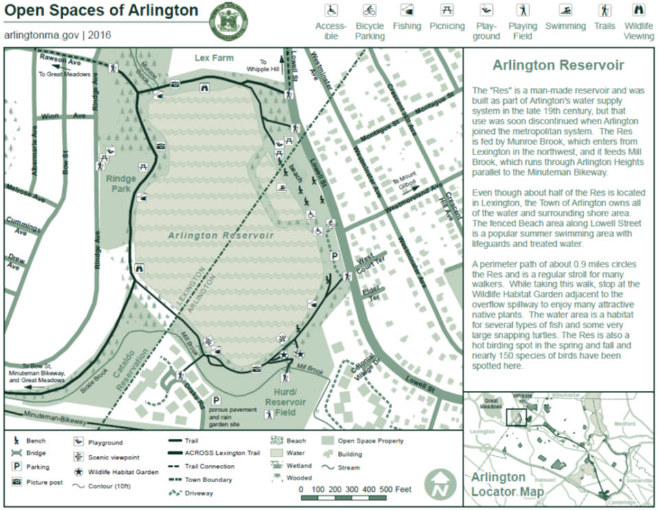
Reservoir Master Plan Annual Report for 2016 2016 was a busy year for the Arlington Reservoir Committee. The Wildlife Habitat Garden had its sixth growing season. We also expanded our activities to the “island” in the parking lot and planted, or transplanted, a number of new plants this year. We had help from many people on public monthly workdays - and from many volunteers at other times as well. In spite of the summer drought, the garden came through well with the help of watering volunteers. The garden is for our entire community. We welcome schools, community groups, and others to participate in its growth and evolution. Water chestnut mechanical harvesting continued this summer under the management of the Arlington DPW, but was hampered because of low water levels. In addition the Mystic River Watershed Association (MyRWA) had corporate and public hand harvesting events in the spring and fall. We hope to increase these volunteer efforts in the future. Seasons of the Arlington Reservoir, an art show organized by the Res Committee, was on display from September 9 through October 27 at the Arlington Town Hall. The show featured oil paintings, color photographs, black and white photographs, collage, mosaics, and digital imagery. Over 20 local artists from both Arlington and Lexington participated. The exhibit celebrated the Reservoir being the "park of the month" in September, and showcased many reflections of “The Res” from around the year. Images included the Reservoir in winter with ice covering the surface, in springtime with new greenery, in fall with colorful foliage and reflections in the water, walkers and runners on the paths in all seasons, and of course in summer with bathers at the beach. The show was well received and helped broadcast more widely the natural and recreational wonders of the Reservoir. Special thanks to Cristina Burwell, Cathy Garnett, and Martine Gougault for organizing the many details associated with putting on such a show. Picture Posts Now at the Res Reservoir Scrapbook Donations Witch Hazels Arlington Vision 2020 Frequently Asked Questions Boating - Non-motorized boating is permitted on all of the town's water bodies. Canoes/Kayaks are allowed on the Res. There's even a "put in" point just past the vehicle gate as you head toward the wildlife habitat gardens from the Lowell St. entrance. Parking - The parking lots off Lowell Street are available year around. Another access point is from Hurd Field lot (behind Trader Joes) and then a short walk across the field to the Res. Swimming - Swimming is permitted at the Res Beach area during open hours in the Summer. Issues and BackgroundThe 65 acre Reservoir area (the 'Res') in northwest Arlington Massachusetts on the border with Lexington contains the second largest body of water in the town (28 acres). It is a man-made pond originally constructed in 1871 by damming Munroe Brook that flows from Lexington. The dam is an earthen embankment along the southern edge of the Reservoir some 600 yards long and as high as 14 feet (although the water level is much lower). The Reservoir discharges into Mill Brook that flows through Arlington and empties into the Lower Mystic Lake which then feeds the Mystic River. The Res was used as a town water supply until Arlington joined the Metropolitan Water District in 1899.For years the Reservoir served as a popular summer swimming hole until the water quality started to deteriorate. In 1981 a separate swimming area was constructed along the northern side of the Reservoir with filtered water and a sandy beach. The Reservoir is also a popular walking and bird watching spot the year round. In 2006 an emergency spillway was added and the earthen berm reinforced with metal sheeting and concrete. See Dam Project Handout There are several pending issues with the Reservoir:
·
The
Reservoir is heavily infested with water chestnuts that are choking out all
other growth and degrading the habitat for birds and fish.
In recent years, through manually and machine harvesting efforts the
number of weeds has been reduced, and it is hoped that they will be eliminated
completely.
·
The
results of a town wide survey indicate resident concerns about safety,
recreational improvements needed and wildlife habitat maintenance. · Mill Brook, which is partially fed from the Reservoir, is often flooded in heavy rains. |
||||
 |
The Reservoir Committee of the Vision 2020 Environmental Task Group is a group of concerned citizens working to solve the Reservoir's problems. We have monthly meetings. Anyone with an interest in the Reservoir is welcome to participate. | |||
|
|
||||
|
||||
|
Site updated on 08/09/2017 - Webmaster is David E. White -> Email |
||||
We welcome public use and dissemination of the information from this site. Although we believe the information here to be correct, we disclaim legal responsibility for any inaccuracies that might exist. Content material is the copyright of the respective authors. Website design is the copyright of the webmaster. t |
||||